NOAA winter weather forecast map: Which US states could see more rain and snow this year?
Source Entity
Latest News: Todays Latest News Headlines from India & World | Hindustan Times | Hindustan Times
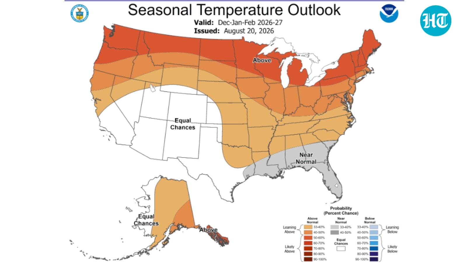
NOAA's winter 2026-27 forecast indicates a strong El Niño pattern, likely resulting in warmer temperatures across the northern United States. Conversely, the southern regions are expected to experience increased precipitation during the December to February period.
Winter 2026-27: NOAA Climate Forecast Overview
The National Oceanic and Atmospheric Administration (NOAA) has released its long-range climate outlook for the winter of 2026-27, providing a critical roadmap for seasonal preparedness. By analyzing current climate signals, specifically the development of a strong El Niño pattern, meteorologists are forecasting a shift in typical weather distributions across the continental United States from December 2026 through February 2027.
The El Niño Influence on Temperature
One of the most prominent features of the latest forecast is the prevalence of warmer-than-average temperatures across a significant portion of the country. The NOAA Climate Prediction Center highlights that the Pacific Northwest, northern Rockies, Plains, Midwest, and the Northeast are all slated for milder conditions. This phenomenon is largely driven by atmospheric circulation changes associated with El Niño, which often push the polar jet stream further north, effectively insulating these regions from severe arctic outbreaks.
Precipitation Patterns and Regional Impacts
While the north experiences a thaw, the southern tier of the United States is bracing for a shift toward increased precipitation. The interaction between the subtropical jet stream—often energized during El Niño years—and moisture-rich air masses typically leads to higher rainfall totals. For communities in the southern regions, this outlook necessitates proactive planning for potential flooding and infrastructure strain, as these areas may face more frequent storm systems throughout the winter months.
Meteorological Methodology and Reliability
NOAA’s seasonal maps are the product of complex climate modeling that accounts for oceanic temperatures, sea-ice extent, and atmospheric pressure gradients. By identifying these early signals, the agency provides a vital service for agricultural, energy, and emergency management sectors. While these maps represent a probabilistic outlook rather than a day-to-day weather forecast, they are essential for assessing long-term climate risks and resource allocation.
Broader Implications for Infrastructure
Predicting a winter defined by regional temperature extremes and localized heavy precipitation has significant implications for national infrastructure. Warmer northern winters can lead to reduced snowpack, impacting water supplies and local winter economies, while increased rainfall in the south may test existing drainage and flood-mitigation systems. As climate patterns continue to fluctuate, the precision of these seasonal outlooks remains a cornerstone of American public safety and economic resilience.
Future Trends and Conclusion
Looking ahead, the 2026-27 winter season serves as a case study in how large-scale climate oscillations continue to dictate regional weather outcomes. As data collection improves, the ability to anticipate these shifts allows for better adaptation strategies. Ultimately, NOAA’s forecast serves as an early warning system, reminding residents and policymakers alike of the importance of staying informed and prepared for the evolving environmental landscape.
Verification Required?