Bihar on flood alert as Nepal rivers swell
Source Entity
Latest News: Today's Latest News Headlines from India & World | Hindustan Times | Hindustan Times
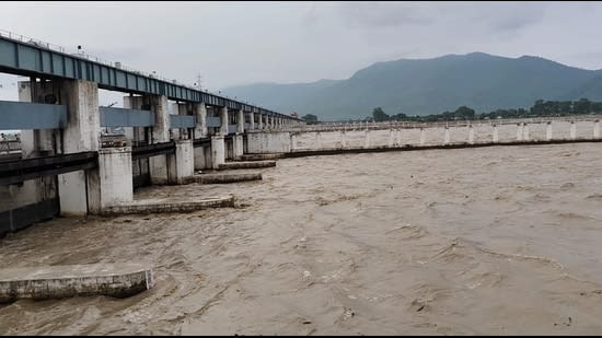
Bihar is on high alert as torrential rains in Nepal cause major rivers, including the Kosi, Gandak, and Bagmati, to overflow, threatening the region with severe seasonal flooding.
Bihar Under Threat: Analyzing the Impact of Nepal's Torrential Rains
Bihar is once again facing the perennial threat of devastating floods as the monsoon season intensifies. The current alert is driven by torrential rains in the Himalayan catchment areas of Nepal, causing a surge in water levels across several transboundary rivers. This seasonal vulnerability is a defining characteristic of the region's geography, where the plains of North Bihar act as a natural basin for the massive runoff originating from the mountains, making the state one of the most flood-prone regions in India.
The Dynamics of Transboundary River Systems
The specific rivers currently in spate—the Gandak, Kosi, Bagmati, Kamla Balan, and Mahananda—are critical arteries that transport vast amounts of water from Nepal into the heart of Bihar. When heavy rainfall occurs in the high-altitude catchment areas of Nepal, these rivers quickly reach their danger marks. This creates a cascading effect where the sudden influx of water overwhelms local drainage systems and breaches embankments, leading to widespread inundation of villages and agricultural land in the low-lying districts of North Bihar.
Historical Context: The 'Sorrow of Bihar'
Historically, the Kosi river has been known as the "Sorrow of Bihar" due to its unpredictable nature and tendency to change its course frequently. Over the last century, the Kosi has migrated significantly westward, destroying countless settlements and altering the landscape. The current alert is a stark reminder of this volatile history; the state's struggle is not merely with the volume of water, but with the inherent instability of these riverbeds, which often carry heavy loads of sediment that raise the riverbed level and increase the likelihood of overflows.
Infrastructure Challenges and International Coordination
Managing these floods requires intricate coordination between the governments of India and Nepal. The strategy has traditionally relied on the construction of embankments and barrages to constrain the rivers. However, these structures are often under immense pressure during peak rainfall and are susceptible to breaches. Real-time data sharing regarding water levels and dam releases in Nepal is crucial for Bihar's disaster management teams to initiate timely evacuations and set up relief camps, highlighting the necessity of diplomatic and technical synergy in water management.
Socio-Economic Implications
The implications of these floods extend far beyond immediate displacement. Bihar's economy is heavily dependent on agriculture, and the timing of these swells often coincides with the growth phase of Kharif crops. The loss of standing crops, livestock, and the destruction of rural infrastructure can plunge thousands of farmers into debt and food insecurity. Furthermore, the recurring nature of these floods creates a cycle of poverty, as resources that could be used for developmental growth are diverted toward annual emergency relief and reconstruction.
Future Trends and Climate Change
Looking forward, the intensity and unpredictability of these flood events are likely to increase due to global climate change. Rising temperatures in the Himalayas are leading to faster glacial melt, while monsoon patterns are becoming more erratic, characterized by shorter periods of extremely heavy rainfall. This trend toward "extreme weather" suggests that traditional embankment-based strategies may no longer be sufficient. There is an urgent need to shift toward "living with the river" strategies, including the creation of flood-resilient infrastructure and improved early-warning systems based on satellite imagery.
Conclusion
In conclusion, the current flood alert in Bihar is a manifestation of a complex intersection between geography, climate, and international water management. While the immediate focus remains on emergency response and the safety of citizens, the recurring nature of these events underscores the need for a comprehensive, long-term basin management plan. Until systemic changes are implemented to handle the Himalayan runoff, North Bihar will continue to remain vulnerable to the whims of the monsoon.
Verification Required?