Cyclone Murasu impact on Telangana | Extremely heavy overnight rain in Bhadradri and Khammam
Source Entity
India Latest News: Top National Headlines Today & Breaking News | The Hindu
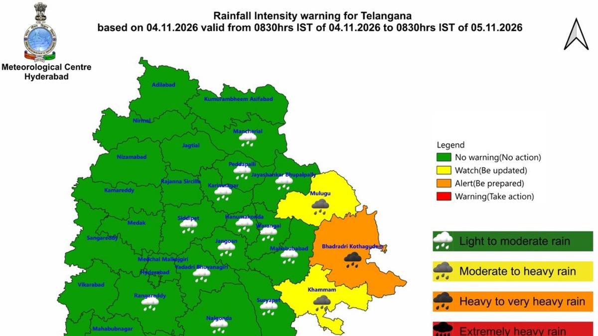
Cyclone Murasu has triggered extreme overnight rainfall across Telangana's Bhadradri Kothagudem and Khammam districts. Authorities report record-breaking precipitation levels, with ongoing weather impacts expected as the system moves through the region.
Cyclone Murasu Triggers Extreme Deluge in Telangana
On November 3 and 4, 2026, the state of Telangana faced significant meteorological distress as the impact of Cyclone Murasu manifested in intense, localized rainfall. Specifically, the districts of Bhadradri Kothagudem and Khammam were placed under a red alert as the cyclonic system brought an unprecedented volume of water to the region. According to the latest data from the Telangana Development Planning Society, the rainfall was not merely heavy; it reached extreme thresholds that pose immediate challenges to local infrastructure and disaster management protocols.
Quantifying the Rainfall Extremes
The severity of the storm is best illustrated by the precipitation metrics recorded overnight. Mulakapalle in Bhadradri Kothagudem bore the brunt of the weather event, recording a staggering 235 mm of rainfall. Similarly, Vemsoor in the Khammam district registered 204.7 mm. These figures place these specific mandals in the 'extremely heavy' category, defined as rainfall exceeding 204 mm. Furthermore, several other mandals across these two districts reported 'very heavy' rainfall, falling within the 150 mm to 204 mm range, indicating a widespread and intense precipitation event.
Disparities in Regional Impact
While the meteorological forecasts had anticipated a broader impact, the reality on the ground showed significant regional variance. Suryapet, which was also under a forecast for heavy to very heavy rainfall, was largely spared from the most intense showers. This discrepancy highlights the often unpredictable nature of cyclonic rain bands, which can shift rapidly and concentrate their energy in narrow geographical corridors. Such localized intensity often makes disaster preparedness and emergency response particularly difficult, as resources must be deployed with extreme precision based on real-time data.
Ongoing Meteorological Conditions
As of the morning of November 4, 2026, the situation remained fluid. Reports indicate that the rain has continued in both Khammam and Bhadradri Kothagudem, suggesting that the system's tail end is still influencing the region. Persistent rainfall following an initial deluge is particularly dangerous, as it saturates the soil, fills drainage systems to capacity, and significantly elevates the risk of flash flooding and waterlogging in low-lying areas.
Broader Implications and Future Outlook
Events like the impact of Cyclone Murasu serve as a critical reminder of the increasing volatility of weather patterns in the Indian subcontinent. The ability of the Telangana Development Planning Society to provide granular, mandal-level data is essential for modern disaster mitigation. As these districts grapple with the immediate aftermath, the focus will likely shift from emergency rainfall tracking to damage assessment, agricultural impact evaluation, and the restoration of essential services. Long-term climate trends suggest that such high-intensity, short-duration rainfall events may become more frequent, necessitating robust infrastructure investments and enhanced early-warning systems to protect vulnerable communities in Telangana.
Verification Required?