Heavy rainfall forecast in 14 Telangana districts on September 21
Source Entity
India Latest News: Top National Headlines Today & Breaking News | The Hindu
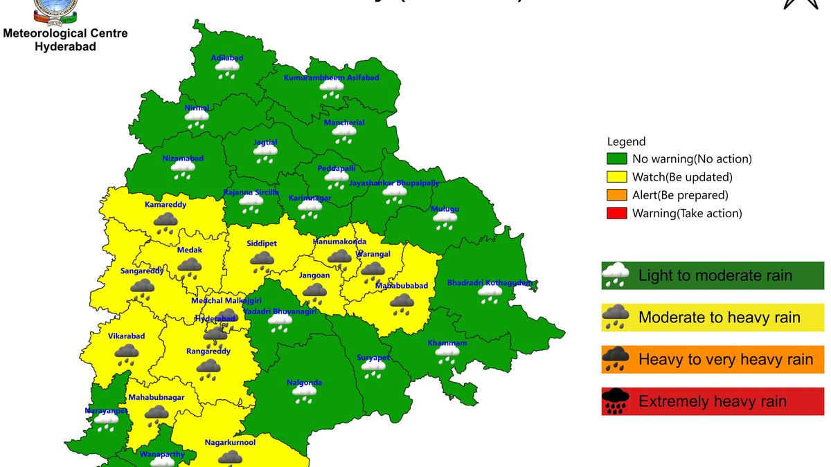
The IMD has issued heavy rainfall alerts for 14 districts in Telangana following recent showers. Simultaneously, a developing depression in the Bay of Bengal is expected to bring squally weather to West Bengal starting September 22.
Weather Alert: Heavy Rainfall Expected Across Telangana and West Bengal
Current Meteorological Overview
The India Meteorological Department (IMD) has issued a significant weather advisory for Telangana, predicting heavy rainfall across 14 districts on September 21. This forecast follows a period of localized precipitation observed on September 20, where areas like Keesara and Kavadiguda recorded notable rainfall, highlighting the volatility of the current weather patterns in the region.
Impact on Telangana Districts
The districts identified for heavy rainfall include Mahabubabad, Warangal, Hanumakonda, Jangaon, Siddipet, Rangareddy, Hyderabad, Medchal Malkajgiri, Vikarabad, Sangareddy, Medak, Kamareddy, Mahabubnagar, and Nagarkurnool. Beyond the immediate threat of heavy rain, the IMD has warned of thunderstorms accompanied by lightning and gusty winds, extending the alert to additional districts such as Yadadri Bhuvanagiri, Wanaparthy, Narayanpet, and Jogulamba Gadwal. These conditions pose potential risks to local infrastructure and daily life in these areas.
Analyzing Recent Rainfall Data
Data provided by the Telangana Development Planning Society (TGDPS) confirms that the region has already experienced significant moisture influx. On September 20, rainfall was not limited to Hyderabad; districts such as Karimnagar, Siddipet, and Kamareddy saw substantial precipitation, with Chintakunta recording as much as 76 mm. This saturation increases the risk of waterlogging and potential flash-flooding as additional rainfall is anticipated.
The Bay of Bengal Depression
Simultaneously, weather systems in Eastern India are shifting. A low-pressure area currently situated over the east-central Bay of Bengal and the adjoining north Andaman Sea is projected to intensify into a depression by Monday, September 21. This meteorological development is the primary driver for the anticipated adverse weather conditions in West Bengal.
Forecast for West Bengal
Beginning September 22 and continuing through September 26, West Bengal is expected to face a spell of heavy rain and squally winds. The IMD indicates that coastal districts will likely bear the brunt of this system. This transition from a low-pressure area to a depression underscores the necessity for proactive disaster management and public awareness in coastal regions prone to cyclonic disturbances.
Conclusion and Future Outlook
The convergence of these weather events—heavy rain in the interior regions of Telangana and the formation of a depression impacting the Eastern coast—highlights the complex atmospheric activity currently influencing India. Residents in the affected districts are advised to monitor official IMD updates closely, as the combination of gusty winds and heavy precipitation can significantly disrupt transport, power grids, and agricultural activities.
Verification Required?