Cyclone Murasu Nov. 3 | Red alert lifted from two Telangana districts; issued for Suryapet, Khammam and Bhadradri
Source Entity
India Latest News: Top National Headlines Today & Breaking News | The Hindu
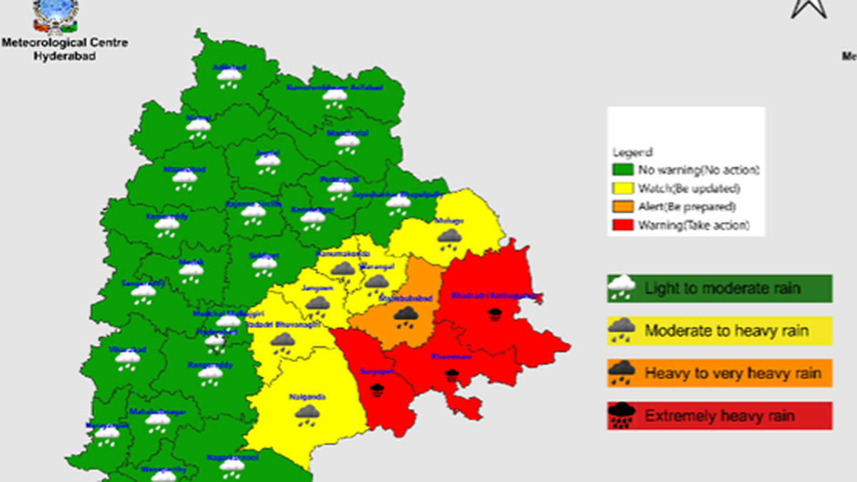
A low-pressure system in the Bay of Bengal is intensifying into a cyclonic storm, threatening the Andhra Pradesh coast by November 2. While coastal regions brace for heavy rain, the system is expected to weaken significantly before reaching inland states like Telangana.
Meteorological Shift in the Bay of Bengal
A significant weather disturbance is currently unfolding in the Bay of Bengal, characterized by a low-pressure area that originated near the South Andaman Sea. According to the India Meteorological Department (IMD), this system is rapidly organizing, with projections indicating an intensification into a depression and subsequently a cyclonic storm by November 1, 2026. This development follows a period of relative calm, marking a renewed phase of atmospheric instability that is expected to impact large swathes of the Southern Peninsula.
Trajectory and Intensity Projections
The system’s path is clearly defined by current meteorological models, which track a west-northwest movement. The IMD anticipates that the storm will reach the west-central Bay of Bengal, specifically the Andhra Pradesh coast, by the evening of November 2. The transition from a well-marked low-pressure area to a full-fledged cyclonic storm highlights the volatility of the Bay during this post-monsoon window, a period historically prone to high-intensity cyclogenesis due to warm sea surface temperatures.
Coastal Impact and Rainfall Forecasts
Coastal Andhra Pradesh remains the primary zone of concern, as the system is forecast to cross the coast on the morning of November 3. Heavy rainfall is anticipated across the coastal belt and parts of the Southern Peninsula, including Keralam, where precipitation activity is expected to resume starting November 1. These regions must prepare for significant moisture influx, which could lead to localized flooding and disruption of daily activities in low-lying coastal areas.
Inland Weakening and Regional Variations
While the threat to the immediate coast is substantial, the inland trajectory offers a different outlook. Meteorologists, including S. Stella of the IMD Centre Hyderabad, have noted that the system is expected to weaken considerably as it moves inland. By the time the weather system reaches Telangana, its cyclonic characteristics will likely have dissipated into a deep depression. Consequently, while Telangana may experience some meteorological effects, the state is largely expected to avoid the most severe impacts associated with the storm's peak intensity.
Broader Implications and Future Trends
This event serves as a reminder of the evolving nature of weather patterns in the Bay of Bengal. The rapid succession of low-pressure systems, occurring shortly after the passage of Cyclone Arnab, underscores the heightened activity levels characteristic of the current season. As these systems move from sea to land, the pattern of intensification followed by weakening highlights the critical role of coastal geography in mitigating or exacerbating storm damage. Future trends suggest that the ability to accurately forecast the rate of decay as systems move inland will remain vital for disaster preparedness and public safety across the Indian subcontinent.
Multiple Citing Sources
Verification Required?