Mapping the Northern Sky
Source Entity
Hacker News
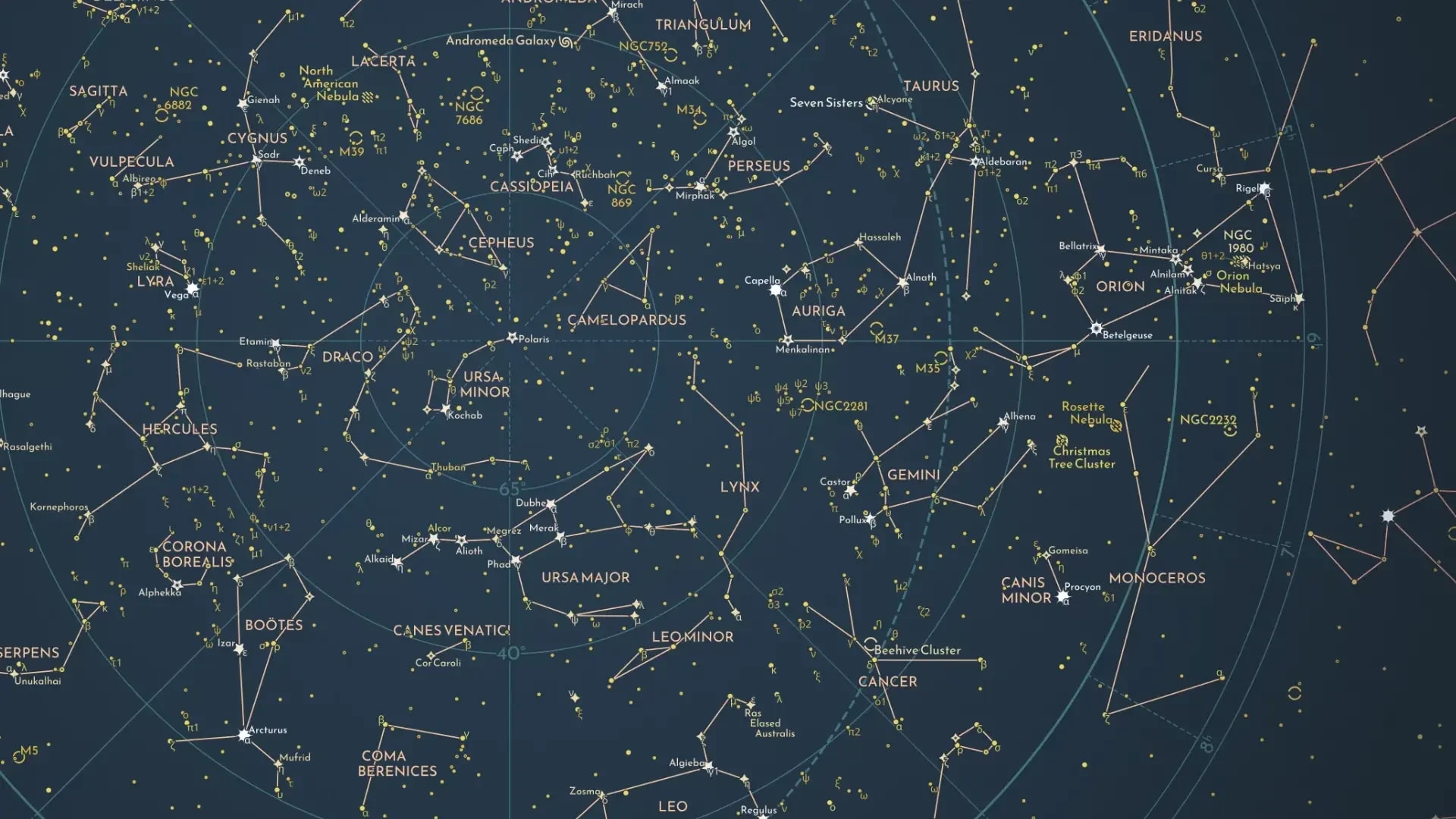
Florian Winkler has created a detailed map of the Northern Hemisphere's night sky using data from Stellarium and the HYG Database. This project continues the historical human tradition of tracking celestial bodies for navigation and storytelling.
The Timeless Pursuit of Celestial Cartography
Since the dawn of human civilization, the night sky has served as the ultimate canvas for both scientific inquiry and cultural storytelling. Long before the advent of modern GPS and satellite-assisted navigation, explorers relied entirely on the consistent, predictable patterns of the stars to traverse oceans and deserts. The ancient Greeks, who famously identified planets as 'planetes'—or 'wanderers'—due to their independent motion against the fixed background of the celestial sphere, established the fundamental framework for how we categorize our universe today.
Integrating Modern Data with Historical Practice
Florian Winkler’s new map of the Northern Hemisphere’s night sky represents a sophisticated convergence of historical observation and modern digital precision. By synthesizing data from Stellarium, the open-source planetarium software, and the HYG (Hipparcos, Yale Bright Star, and Gliese) Database, Winkler provides a comprehensive visual record of the heavens. This project serves as a modern extension of the work done by astronomers for thousands of years, who meticulously tracked star positions to create mental and physical maps for navigation and prediction.
The Significance of Deep-Sky Cataloging
Central to the accuracy of Winkler’s work is the inclusion of W. H. Finlay’s Concise Catalog of Deep-sky Objects. This inclusion elevates the map from a simple representation of bright stars to a detailed scientific reference. Deep-sky objects, such as nebulae, galaxies, and star clusters, are essential markers for amateur and professional astronomers alike. By mapping these, Winkler aligns his project with the rigorous standards of astronomical cataloging that have evolved from rudimentary sketches to high-fidelity digital datasets.
Navigating the Northern Hemisphere
The Northern Hemisphere has historically provided the most consistent navigational markers for early explorers, such as Polaris, the North Star. Winkler’s focus on this specific region underscores the importance of regional celestial mapping. As humanity continues to look outward, projects like this remind us that our ability to traverse the Earth was fundamentally rooted in our mastery of the stars above. This map acts as a bridge, connecting the ancient practice of 'star-gazing' with the data-driven reality of modern astrophysics.
Future Trends and the Digital Sky
As we look toward the future, the digitization of the night sky via projects like Winkler’s becomes increasingly vital. With the rise of light pollution, many urban observers are losing their connection to the natural night sky. Detailed, accurate maps serve as a critical educational tool, preserving the visibility of celestial phenomena that may be difficult to discern with the naked eye in modern environments. This trend of digital archival ensures that the 'mental map' of the heavens remains accessible to future generations, regardless of their geographical location or access to dark-sky sites.
Conclusion
In summary, Florian Winkler’s mapping project is a testament to the enduring human fascination with the cosmos. By combining historical cataloging techniques with contemporary digital databases, he has produced a resource that is both scientifically valuable and culturally significant. This work not only honors the explorers of the past but also provides a necessary tool for the stargazers and scientists of the future, ensuring our map of the heavens continues to guide us.