Is a major storm coming? Severe thunderstorm alerts issued across US states; hail and flooding risks rise
Source Entity
Latest News: Todays Latest News Headlines from India & World | Hindustan Times | Hindustan Times
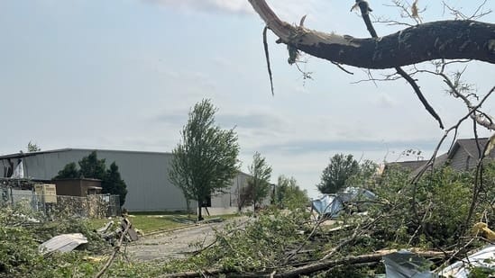
Severe thunderstorms are sweeping across multiple U.S. regions, bringing threats of damaging winds, large hail, and flash flooding. The National Weather Service has issued watches for areas including the DMV, Colorado, and North Carolina as storms intensify.
Severe Weather Systems Threaten Multiple U.S. Regions
Current Meteorological Situation
The United States is currently facing a volatile weather pattern characterized by widespread severe thunderstorm activity. According to the National Weather Service (NWS), these systems are producing significant hazards, including high-velocity damaging winds, large-diameter hail, and torrential rainfall. The rapid intensification of these storms during the afternoon and evening hours has necessitated the issuance of severe thunderstorm watches across geographically diverse regions, specifically the DMV (District of Columbia, Maryland, and Virginia), Colorado, and parts of North Carolina.
Regional Impacts and Hazards
The impact of these storms is already manifesting in physical destruction. Reports from Fox Crossing, Wisconsin, serve as a stark indicator of the potential severity, where fallen trees and structural damage followed a tornado strike. In the DMV region, local authorities and outlets like WJLA have maintained active severe thunderstorm watches through the late evening, specifically highlighting the dual threat of wind damage and the potential for isolated tornado activity. The combination of saturated ground and intense rainfall rates significantly elevates the risk of flash flooding in these areas.
The Mechanics of Rapid Intensification
Forecasters have noted that these storms possess the capability to strengthen rapidly, a phenomenon often driven by atmospheric instability and moisture transport. When warm, moist air meets cooler, unstable air masses, the resulting convective activity can lead to the sudden development of supercell structures. These structures are frequently responsible for the large hail and damaging wind gusts currently being reported by the NWS. The rapid nature of this development leaves limited window for public response, making the NWS watch system a critical tool for community safety.
Historical Context and Climate Trends
While severe weather is a seasonal expectation in many parts of the U.S., the breadth of these current alerts underscores the dynamic nature of atmospheric conditions across disparate regions like the Rocky Mountains and the Mid-Atlantic. Historically, the transition of seasons often acts as a catalyst for such high-impact weather events. The current situation highlights the persistent vulnerability of infrastructure to extreme wind and precipitation, as seen in the localized damage reported in Wisconsin.
Future Outlook and Preparedness
As these storm systems continue their trajectory, the risk of flooding remains a primary concern for emergency managers. Urban areas with limited drainage capacity are particularly susceptible to flash flooding during intense downpours. Residents in the affected regions are encouraged to monitor local NWS updates closely. Looking ahead, the frequency of such intense convective events requires continued investment in early warning infrastructure and community preparedness to mitigate the risks posed by damaging winds and sudden flooding events.
Verification Required?